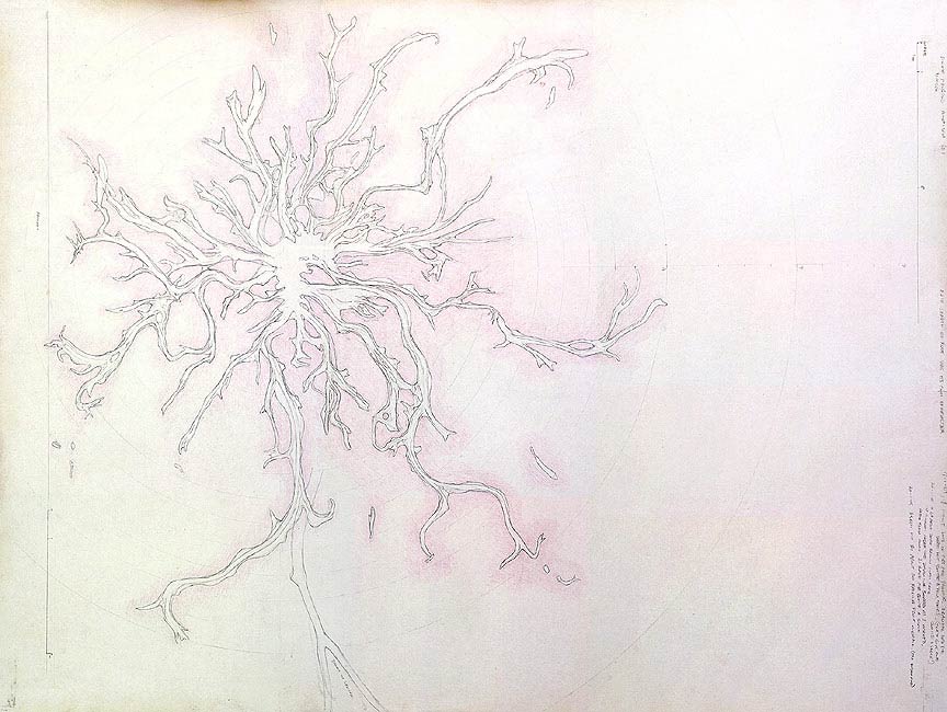
74 cm (w) x 55 cm (h), graphite and watercolour pencils on cartridge paper.
Date produced: 3rd March 2005
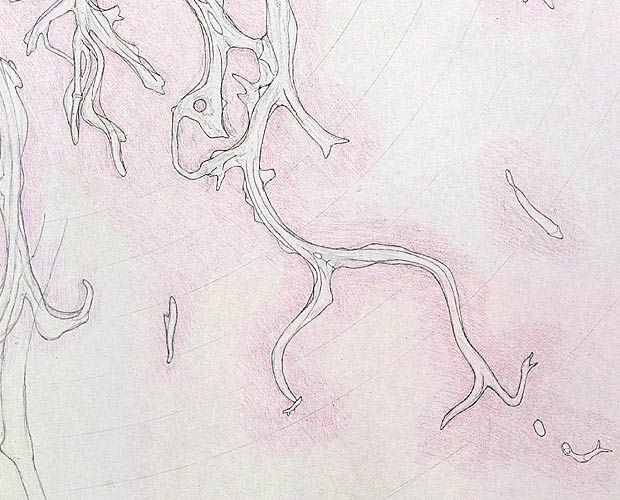
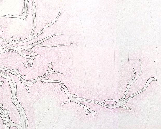
This was drawn entirely on-site. I wanted to produce a map of the exposed buttress roots of the tree, to see what overall patterns and shapes resulted. I used a crude surveying technique to get reasonable overall accuracy. Note the series of concentric rings which were drawn on lightly before any recording, to aid the crude surveying. This drawing took about 4 weeks of work. Having worked on this map for about 3 weeks longer than I thought it would take, I realised that such a map is extremely relevant to this project; so relevant, that the idea was expanded to attempt a map of the main lower boughs of the tree, including the canopy shape, to go along with this map of the exposed buttress roots. While doing this drawing, it was quite common for falling fruit to fall directly onto the drawing (which was usually lying horizontally), making very loud and unexpected noises like guns being fired. These falling fruit also left little round pink marks on my drawing.
How I surveyed the roots:
I started by assigning a point on the tree as the centre, and measured out from that point using a string with regular markers, at intervals of one of my average ‘strides’. I used ‘strides’ because they were convenient. I measured out 8 strides along the string then divided that amount into 8 equal sections by halving that measure 3 times. I then copied those 8 strides to the next length of the string, so that I had enough to measure out to the furthest buttress roots, at around 15 strides. By staking the string from the centre point to the various buttress root arm ends, I could get a resonably accurate measure of the roots and their features from the centre point. The angles of these staked lines were cross-checked using ‘strides’ to known reference points (such as the straight pathway that runs underneath the tree). At all times, I used my judgement of proportion and drawing analysis skills to further check the developing map. I used a long cord, with measured marks to accurately record ‘highlight’ points of the roots. This cord was mainly used as a radiating line from an arbitrarily chosen centre point on the tree. However, triangulation was used to cross-check the positions of the outer points. The smaller sections of curves between the accurately measured highlight points were then drawn from observation, standing directly above those sections. I needed to erase and redraw all parts of the map several times, starting with simple representative lines for the buttress roots, and eventually developing accurate indications of the true contours, shapes, and thicknesses of the many interconnected parts.
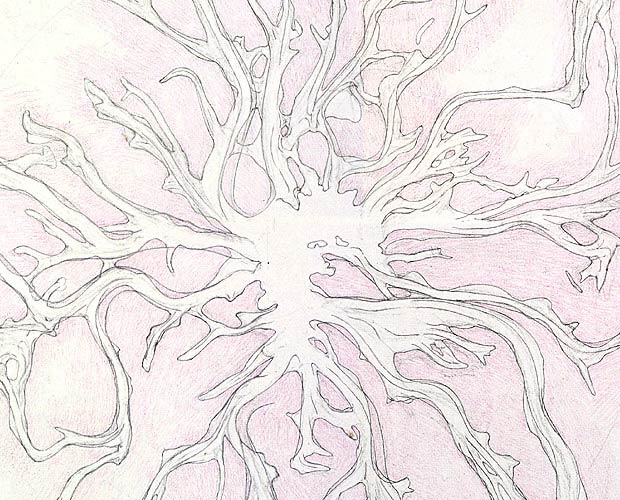
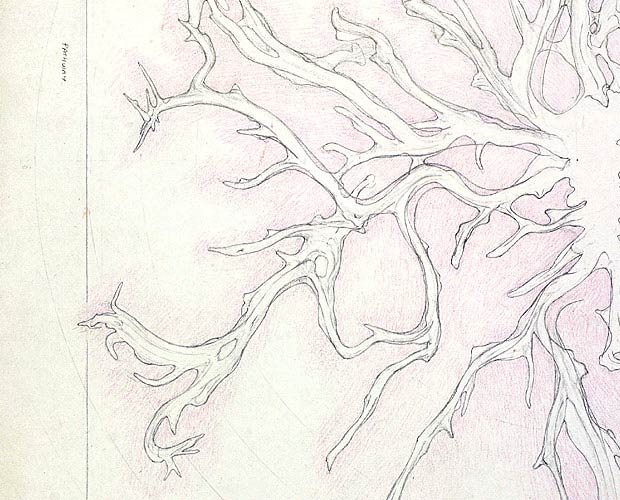
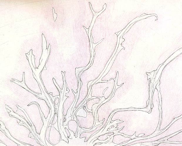
Very early on, I realised that there were different shapes of the roots at ‘ground level’ to the overall shapes seen from above. I have tried to show these things when they have differed significantly, by colouring around the ‘ground level’ shapes with pale purple, leaving overall contour lines as just lines. I have also indicated significant features related to the forms of the buttress roots, like ridges and ‘hollows’. These things can be more easily seen in the detail images. I discovered a number of things while doing this drawing. From a visual point of view, I discovered that the shapes within the buttress roots seen from directly above are usually quite different from viewing the roots from an oblique angle and applying some intellectual compensation for the oblique angle. One really had to view things from directly above, which I did, apart from several places where I really couldn’t get above them properly (because of overhanginging boughs). I was very surprised by the number of root arms that joined in loops with other root arms, making ‘pools’. I was expecting that most root arms would be independent structures, generally just radiating out from the centre of the tree. These joined roots would be providing much more strength within the buttress root structure. How would they have formed though? Will the roots happily join if met by another from the same tree? How will the tree know if it the connecting root is one of its own? I was also surprised by how little ‘cross-section’ went into the ground near the centre of the tree. Yes, there is a bit of a shape in the centre, but compared with the amount of timber one sees with all of the huge main boughs spreading out, I was still surprised - there were many hollows that seemed to be keeping the core as small as possible. As I worked at recording the various buttress roots, I wondered about what the determining factors were that resulted in the roots growing as they had done - pre-determined genes, growth rates, the slopes within the ground around the tree, the location of nutrient supplies, availability of water (over the years), water drainage over the years, available sunlight (which will be changing through the seasons, and as a result of the tree’s own foliage), orientation to the sun, gravity(? perhaps), the influence of other trees (other trees’ roots, and other trees’ shadows), the influence of local insect populations, the prevailing winds and influence of storms (stressing the tree in certain ways and at certain consistent points), etc., etc. It is likely to be an extremely complex and delicate balance of cause and effect.
|